


Direction
Getting to Grand Teton National Park is pretty straight forward. Any modern GPS system (such as Google Maps or Waze) will provide directions to the local ranger stations. I recommend doing this trail South to North, however the opposite is possible as well.
Drive to Jackson Hole mountain resort in Teton Village. Find the Ranch parking Lot (see map for further details) where you can park your car overnight for several consecutive days.
From there, you can choose to hike up 6 miles / 4,000ft to the top of the ski lift or buy a lift ticket ($40/ticket in August 2017) to the top of the mountain (called Rendez-vous Mountain). We opted for the latter, as it was already late in the day.
The trek ends at Jenny Lake. From there, a bus runs on a regular basis during daylight hours. This shuttle rides all the way back to Teton Village which is a convenient way to get back to your car upon completion of the hike. You can also arrange for a second car or choose to hitch hike. I recommend checking the shuttle's availability as it may vary depending on the season.
Introduction
The Teton Crest Trail is one of America's most famous trek. It crosses Grand Teton National Park from North to South (Or the reverse, which is the most famous route). This trail runs through some of the most epic scenery of the west: wide grassland fields, mountain passes, rugged peaks, dense forests, lakes, rivers etc..
Being in the heart of Wyoming, this trail is typically walked in the Summer or late Spring/early Fall. Seasons are short in Wyoming and winter conditions arrive early with continuous snowfalls starting in October. One could venture in this wilderness in the winter but would need appropriate gear and skills for such conditions.
While there are several variations of the trail, this trip reports the most common one. It consists of a total mileage of 34 miles with a total elevation gain of roughly 7,400ft. We did this trail in 3 days, you might add/deduct a few days, based on your aspirations and physical condition.
I recommend checking the latest conditions as snow can be present all year round. Ask specifically about the conditions at Paintbrush Divide, as this area tends to retain more snow and may require crampons or spikes to cross.
Wildlife in the park includes grizzly bears and moose, so it is best to do this trip with a group of 3 or more people or to carry bear spray and have it readily available. We had initially planned to complete this trail in 4 days, however we encountered a full grown bull moose at our campsite the last night who didn't seem to enjoy our presence. This encounter prompted us to leave earlier and finish the few remaining miles at night.
Permits are necessary as campsites along the trail are designated. Permits are available via a lottery system or as a first come-first served basis at one of the local Ranger Station. If hiking in July/August, I recommend arriving at the Ranger Station before it opens in order to score your preferred campsite as competition might be running high.
Please note that this is a one way trip. You might want to accommodate for a second car to wait at the end of the trail. Otherwise, a Shuttle service is available during daylight hours at Jenny Lake.
Day 1 - Teton village to Death Shelf Canyon
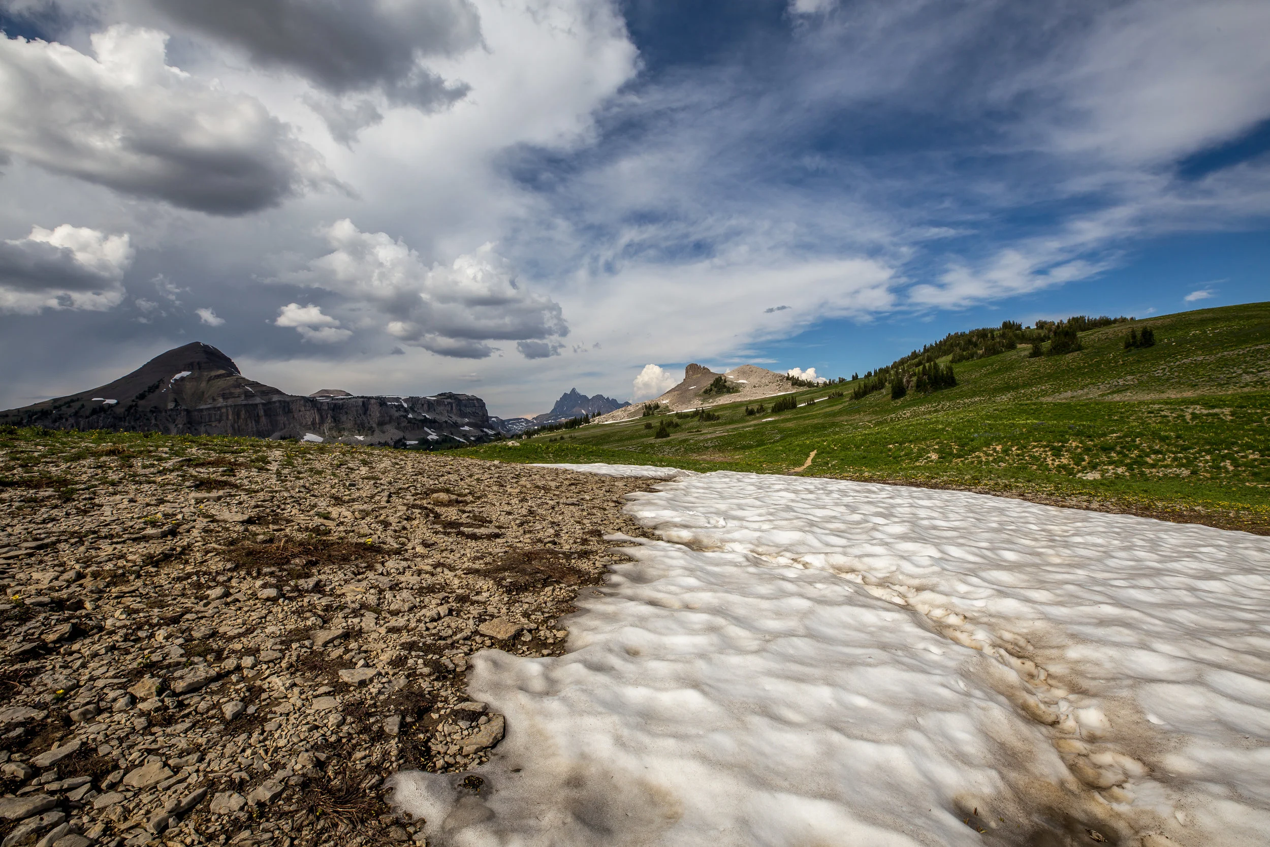
From the top of Rendez-vous Mountain (10,500 ft), we took the Rendez-vous Mountain trail. This trail narrows down for 2.8 miles / 2,000ft and joins the Middle fork cut-off trail which connects to the Teton Crest trail after 0.6 miles. From there, a magnificent valley of lush green grasslands, snowy mountain tops and pine trees opens up. Walk for another 2.9 miles to Marion Lake which sits at 9,300 ft below a glacier.
From Marion Lake, we walked another 4 miles to Death-shelf Canyon, a narrow rocky plateau, bordered by a steep wall on one side and a deep valley on the other. We set up camp near a stream and enjoyed a hearty dinner while watching the sunset.
The views that day were beyond what words can describe. I suggest that you take a peak at the pictures below in order to get an idea of what to expect.
Terrain profilE for Day 1


Day 2 - Death Shelf to the North Fork
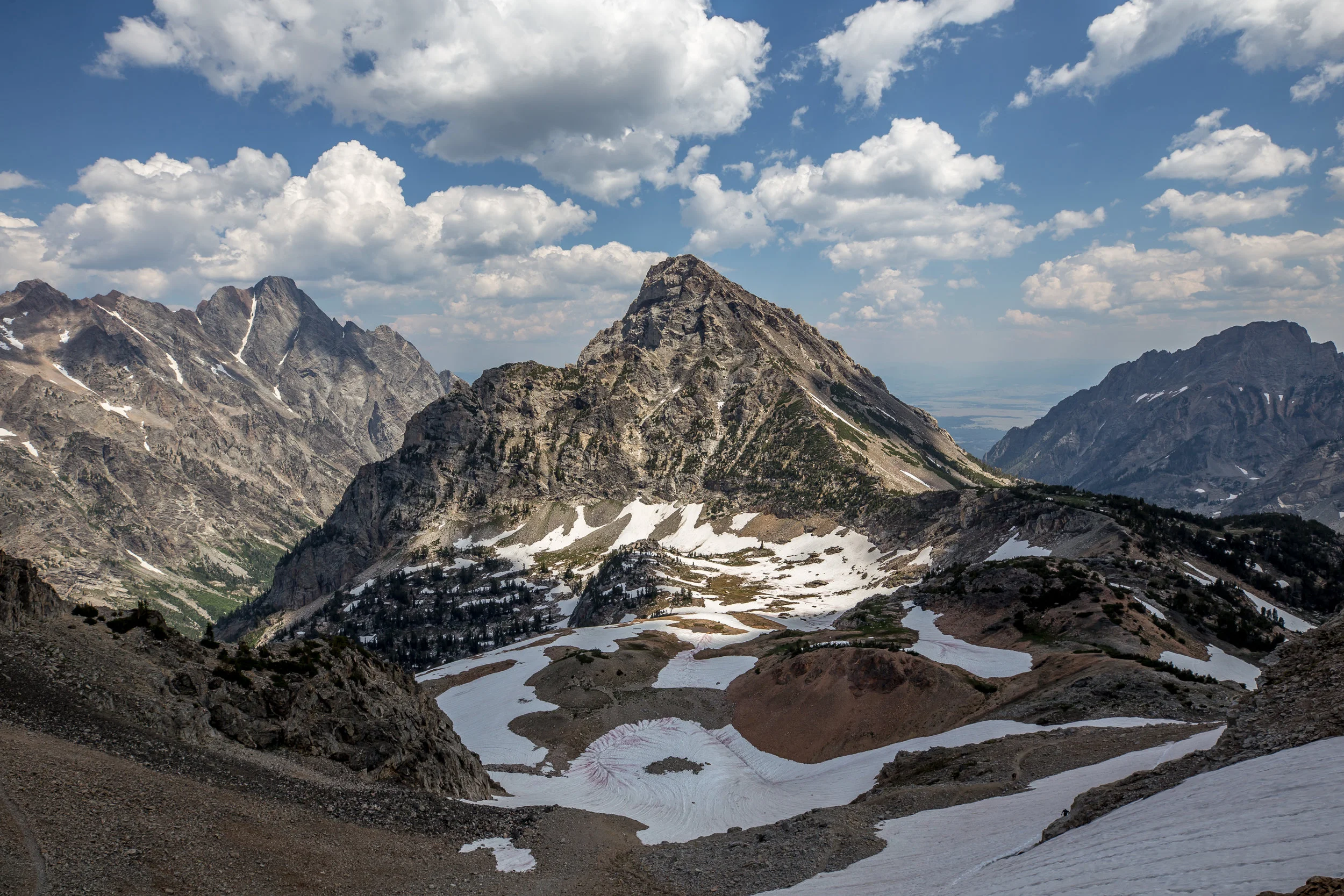
The second day was a long 13 miles hike with 2,700 ft of gain and 3,600 ft of loss. The first 2.5 miles of the trail consist of the last stretch of Death Shelf Canyon. Then, a 500 ft descent called sheep steps took us to a lush green valley called Alaskan Basin, featuring several small lakes, and divided by the south fork creek (not requiring any deep crossing). The landscape there is absolutely astonishing and provides for a 360 view of the nearby snowcapped peaks, canyons, wide grassy fields and scattered pine trees.
From there, the trail took us for a 3 miles / 1,250 ft gain hike to Hurricane Pass. One of the highest point of the hike, it features wide views of the Tetons and is good place to rest.
We then descended a steep rocky path on the other side of the pass, which led to join the South Fork trail, a trail which runs across the South fork river across a dense forrest. It features several campsites, however none were available when we had initially booked our permits. The south fork trail runs for 5 miles and the total descent from Hurricane Pass to the end of the trail is 3,250ft, featuring a drastic change in landscape and climate.
After reaching the lowest point of our day at 7,800 ft, we joined Lake Solitude trail which runs along Cascade creek and took us for another 2 miles to our campsite. We enjoyed a cold bath in the north fork river and a hearty meal, while glancing at Grand Teton.
Download Terrain Profile for Day 2
Alaska Basin


Views of the Teton from Hurricane Pass

Alaska Basin

South Fork Trail

South Fork Creek


Day 3 - North Fork to Jenny Lake (via Paintbrush Canyon)
This day totaled 11 miles, 2,425 ft of gain and 4,200 ft of descent.
We started by hiking up towards Lake Solitude (9,035 ft), a lake filled by glacier up to and feeding Cascade creek. We then joined Paintbrush Divide Trail, a steep 2-mile rocky trail which took us all the way to Paintbrush Divide, a beautiful Pass at 10,750ft, which separates North Fork Canyons and Paintbrush canyons. After taking a multitude of pictures and enjoying the view, we made our way down the eastern side of the pass. the trail was extremely steep and completely covered with snow, requiring the use of crampons. After a careful crossing, we met a ranger who was sitting on a rock looking at people making the dangerous traverse (sometimes with inappropriate gear). We sarcastically asked if he was waiting for an accident to occur, to which he answered positively.
From there, the trail winds down towards Holly Lake (which features several campsites) and Paintbrush Canyon. We noticed that mosquitoes were quite aggressive at Holly Lake as they were in most lakes below 10,000 ft of altitude. We hiked another 2 miles and set up our last camp. We climbed a rocky outburst above our campsite to have dinner and sip some whiskey when suddenly, a full grown bull moose entering our camp (no food was present since we had everything in our beard canister) We tried to wait for him to leave, however he seemed very much unafraid of our presence. We then spotted a few deer by our tent. It seems those animals were set on having a party. We decided to pack and hike the remaining 4 miles in the dark.
The last few miles consisted of a thick and dense forrest. We hit Leigh Lake and starting seeing signs of a nearby civilization. After another hour, we finally reached the parking lot at Jenny Lake where we hitch hiked back to our car at Teton Village for a well deserved beer!
Terrain profile for Day 3

View from Paintbrush Divide
Paintbrush Divide

Paintbrush Canyon Trail

Paintbrush Divide


View of Jackson Lake

Gear
HARDWARE
Pack
Sleeping bag
Sleeping Pad
Tent (3-season)
Flashlight
Poles
Ice Axe
Microspikes
Crampons (recommended in heavy snow conditions)
CLOTHING
Base layer
Mid layer
Down Jacket
Softshell jacket (winter only)
Softshell pants (winter only)
Hardshell
Shoes
Gloves
Socks