

Mount Sterling & Cosby Knob

Directions
The trailhead is located in the northeastern part of the park, near Big Creek Campground. There are many ways to enter the park depending on where you are coming from. Regardless, you will at some point end up on highway 40, which crosses the eastern flank of the park. From Highway 40, take exit 451 onto Waterville Rd. Follow Waterville Rd for 3 miles. The road then becomes Big Creek road. You will see a country store as well a ranger station (not opened year round). Follow Big Creek Road to Big creek Campground for another mile. You can park your car at the campground. Pay attention as parking is limited and fills up quickly. I recommend getting there as early as possible in order to secure a spot. Make sure to display on your dashboard your entrance fee payment or your annual pass.
You will need a backcountry permit in order to secure camping sites. You can obtain your permit by following this link. I recommend reserving your permit long in advance as this is a popular area that fills up quickly.
Introduction
Living on the west coast, I have always had my attention focused on adventures located West of the Rocky Mountains. However, being a History buff, the Great Smoky Mountains had always inspired me. They area bears stories that go back well before the first European explorers mapped the west. From tales of the American Revolution to stories of Civil war heroes, the Great Smoky Mountains carry an aura that is different from anything found in the West. It was once called the western frontier, back when the US were just 13 colonies. It used to be populated by thriving Native American tribes, which controlled the land and had established an extensive network of trade between the French, the British and other European colonial powers. As Lewis & Clark made their way up the Missouri river in 1806, the frontier slowly started shifting westward. Today, the Great Smokies are a simple range of mountains located on the east coast with a hight point that rises at 6,643ft above sea level.
It is not the elevation of its peaks that make the Great Smokies shine. It has none of the grandiose of the great western mountain ranges: no high towers of granites, no glaciers, large open space natural meadows surrounded by towering peaks. It has none of that. But it has that unique character mentioned in its name: Low clouds often creeps at night between the peaks, creating this mystic landscape, as if smoke was trapped within the peaks. The Great Smokies are as mystical of an ecosystem as you’ll find out west.
In the Fall of 2017, I flew into Atlanta to meet my brother and we planned ou trip to Great Smoky Mountains National Park. I chose a route that would lead us across a wide variety of features over three days, allowing us to witness some of the highlights of the park.
Day 1 - Baxter Creek to Mt Sterling
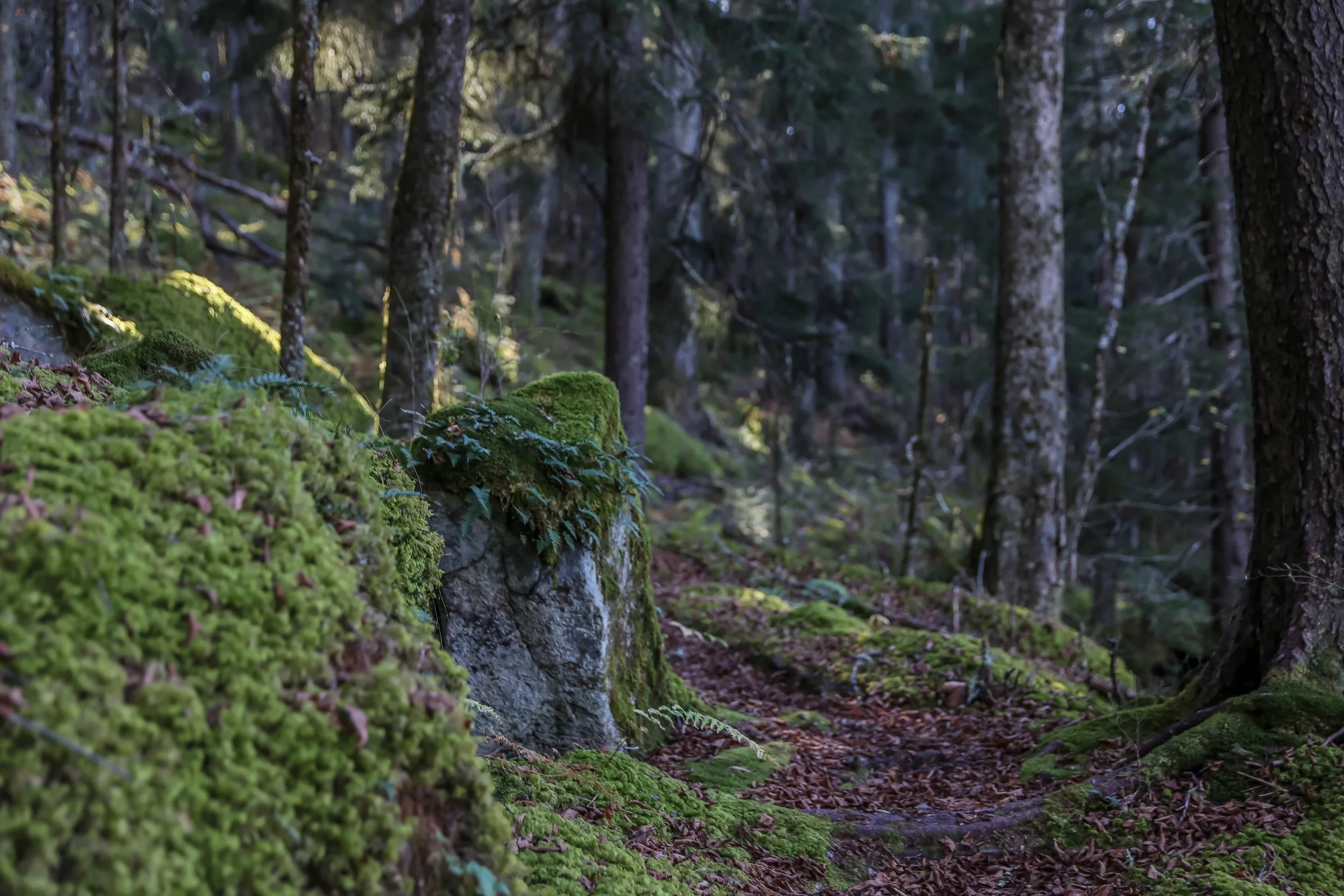
We started our day by heading up Baxter Creek trail. The trail took us for almost 6 miles up 4,000 ft of elevation gain to the summit of Mount Sterling. The trail is stunning and took us through dense lush forests. It was Fall and the ground was entirely covered with yellow and brown fallen leaves. The relatively high level of humidity (it had rained a few days earlier) and the leaves on the ground made the soil quite soft, which was welcome treat for our feet and knees. This is striking contrast with the Sierra Nevada where everything is made of rock and granite.
With several streams flowing along the way, water was readily available, therefore that is not something we were worried about. It is hard to walk along this trail and not think of the movie “The last of the Mohicans” ( which was filmed in the Great Smoky Mountains).
This trail is famous as it was used as a hideout during the Civil War by deserters of both the Union and the Confederacy. Both armies would launch raids in order to capture deserters, however the steep terrain and remote location made these attempts difficult. It was one of the rare locations where both sides would get together in a peaceful fashion.
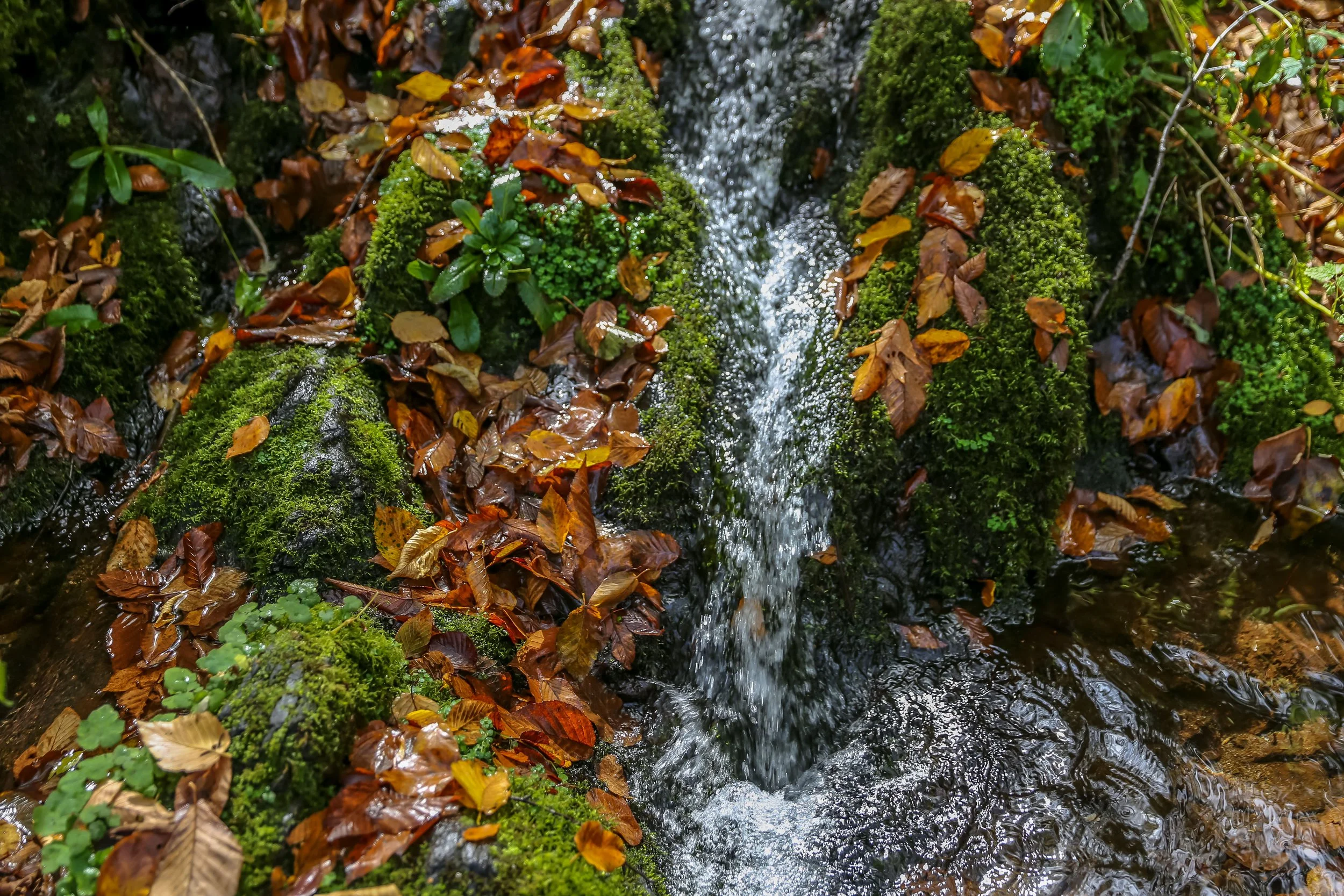
The trail does not offer any wide views of the surrounding mountains, yet this remains a paradise for photographers, as testified by the photographs below. After the steep hike, we finally made it to Mt Sterling. At the summit lies a tower built by the National Park Service. We climbed it and it felt relatively safe. The view is stunning and as the sun set down, we could glance for the first time at the Smoky Mountains.
Several campsites are available on top of Mount Sterling on a first come - first serve basis. We cooked dinner over a fire that night (check for fire regulations), drank a gill (4oz) of Bourbon and called it a night.
DOWNLOAD TERRAIN PROFILE FOR DAY 1


Day 2 - Mount Sterling Trail to Cosby Knob
The second day would take us down a valley where Big creek river flows, and up another ridge to the legendary Appalachian trail. Atop Mt Sterling, we headed south for 1.7 miles (700ft loss) on Mount Sterling Trail. Baxter Creek Trail (the trail we had followed on Day 1) becomes Mount Sterling Trail when going south. The trail took us alongside a mountain ridge dominated by dense trees with little views of the surrounding mountains This area seem to be under forrest management. We reached an intersection and then headed west down Shallow Fork trail. Shallow Creek trail is relatively narrow and drops down 2,200ft for 4 miles to Big creek. This is a beautiful and secluded trail. The thickness and density of the trees only allow for a few rays of sunshine to pass through, making the surrounding colors soft and clear. I noticed the temperature and humidity go up significantly while going down into the valley. We were doing this hike in the Fall. I can only imagine how hot and humid it must get during the summer. that is something to take into consideration when hiking during the hot season.
We took a break at Big Creek and headed up Low Gap trail towards the Appalachian Trail. Low Gap trail is the continuity of Shallow Fork Trail and is a steep trail that took us up to the Appalachian ridge for 1.3 miles and with 1,300 ft of elevation gain.
Finally! We had reached the Appalachian Trail. We glanced at the majestic valley we had just crossed. Behind us lies Mount Sterling with its noticeable tower, visible in the distance. To the west, we can see the endless Smokies. We followed the Appalachian Trail southward for another 1.2 miles (800ft of elevation gain) to Cosby Knob. Cosby Knob is one of these remote wood shelters that lie on the Appalachian trail. People sleep next to one another on wood shelves and camping is usually prohibited (unless specified). There are cables to hang your food away from the bears and fire rings to make a fire.
Dont expect to find seclusion at one of these shelters. If the crowd is right however, this can make for some entertaining evenings.
We cooked some food, relished at the beautiful day we just had while sipping on some bourbon and went to bed.
DOWNLOAD TERRAIN PROFILE FOR DAY 2


Day 3 - Cosby Knob to Big Creek trailhead
This was our last day, yet not a short one. We had a total of 9 miles to hike, with over 4,000ft of elevation loss.
We woke up before dawn and set out on the Appalachian trail heading north.
The first 3 miles consisted of a moderately flat hike along the Appalachian ridge. We were blessed with a red sunrise which provided some of the most vivid Fall colors I had ever witnessed. We took a detour by Mount Cammerer. Located at 5,000ft, it is one of the highest point in the park, A tower provides 360 degree views of the surrounding mountains. It is a perfect location to witness a sunrise or a sunset over the Great Smokies.
From there, the trail goes downhill all the way until the end. We hiked another 3.5 miles with 2,200 ft of elevation loss and reached the intersection between the Appalachian Trail and Chestnut Branch Trail. Chestnut Branch is a secluded narrow trail which took another 2 miles and over 1,200 ft of elevation loss to Big Creek Entrance road. Upon reaching the road, we hiked up the road for another 1/2 mile to Big Creek Campground, and back to our car.
Our adventure ended at this point. It was my first time in the Great Smokies and it was quite a change from the landscapes of the West. Fall and Spring seem to be the ideal seasons to venture in these mountains, mainly because of the mild weather and smaller crowds. Summer can get crowded, hot and humid. Winters are cold and snowy but can make for an epic adventure if one is willing to venture at this time of the year.
DOWNLOAD TERRAIN PROFILE FOR DAY 3